Ironbark and Werribee Gorges
Walk overview
Length: 12.0kmTime: 4.5 hours
Grade: Medium to hard
Ascent: 405m
Maximum height: 360m
Region: Goldfields, Victoria
Map: Meridien Productions 1:20,000 Lerderderg and Werribee Gorges
"The dominant geological feature to the west of Melbourne is the Rowsley Fault. East of this fault lies the plains surrounding Port Phillip Bay while to the west is the uplifted plateau that extends to Ballarat. The Werribee River has cut deeply into this plateau creating a rugged steep-sided gorge."
"A series of walking tracks and foot pads visit most of the major features and this walk negotiates both Werribee Gorge and the subsidiary Ironbark Gorge."
Source: Day Walks Victoria
My comments
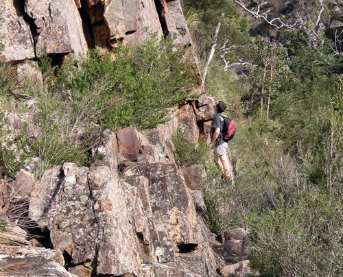
We almost always get lost on our walks, and today was no exception. We missed Ironbark Gorge either by taking the wrong track right at the start of the walk, or by missing a turn - we're still not sure where we went wrong. However, our navigation error turned out to be rather serendipitous (Chris P managed to get just the right word) as we found our way to the spectacular views offered by Falcons Lookout - aptly named as Chris J soon spotted a falcon.Chris P had an older walking book that showed a path from the lookout down to the point where Ironbark Gorge meets the river, so we took that option to rejoin the original route. On a steep rocky climb down, Chris J managed to burst the zip of his backpack, sending his water bottle spiraling down. As luck would have it, Chris P managed to spot it at the bottom and hop across some rocks to retrieve it.
Crossing the river wasn't straightforward. Because we weren't sure we'd reached the river at the right point to cross (it certainly wasn't crossable here), we took a vague track around the edge of a cliff face to see if we could find a suitable crossing. Chris P scarpered off across a fallen log that provided a bridge over the river and promptly disappeared. In the meantime, Chris J and I found ourselves in the middle of a swarm of bees, one of which managed to get tangled in my hair, stinging me on the scalp in the process! Chris P soon returned saying he'd been able to cross the river and find the track on the other side. So over the river on the log we went. My knees were knocking by the time I was back on terra firma. Although the log was suspended only a metre or so above the water, the thought of falling into a freezing cold rocky-bottomed river carrying pack full of gear and camera didn't appeal.
We soon found Needles Beach, a sandy oasis with a fantastic rocky gorge cliff-face as a backdrop and then continued on around the river, scrambling over rocks and negotiating a few rocky ledges--one even had a line bolted into the rockface to hang on to--to reach Lions Head Beach.
We then walked alongside an old aqueduct for a couple of kilometres, marvelling at the effort it must have taken to build it in such difficult terrain, before heading up to the quarry picnic area where we stopped for a short while for lunch.
The next part of the walk took us along the top of the gorge to the Eastern Lookout, where we could see back over the east to the city--on the horizon in the far distance--and then Picnic Point where we had a fabulous view of the gorge and winding river and the walking route we'd taken during the morning. It was quite impressive!
After a long, rocky descent we made our way back to Needles Beach, running into some stinging nettles along the way. A discussion on the beach saw the guys keen to cross back over the river and walk back via Ironbark Gorge, while I was more inclined to take the route up over the Western Bluff. After a consensus decision to do the gorge, my inability to tackle the log crossing had Chris P hunting around for other crossing options before we gave up and decided to go over the Bluff. We headed back around past Needles Beach, back over the rocks to a point on the river where we were able to cross over rocks to reach the vaguely defined track leading up to Western Bluff.
It was a tough way to end the walk. Mostly uphill, and a good deal of it on a very thin, rocky ridge. But we all felt a real sense of achievement when arriving back at the cars.
I haven't felt this tired after a walk in a long while. It took us 6.5 hours rather than the 4.5 quoted. While taking the wrong route at the start might account for 15-20 minutes extra time, and our attempts to cross the river to take the Ironbark Gorge route back might have cost a similar amount of time, we still have over an hour of extra time to account for. We certainly weren't dawdling or stopping for long breaks. I also thought there was more than 405m of climbing involved. But maybe it was all the adrenaline caused by my fear of heights, maybe a fear of logs or log-bridges?
My rating
Excellent. This is a really beautiful walk through spectacular scenery--the rock faces of the gorge are wonderful--and many changes of vegetation. A little hairy crossing the river, but definitely a walk to do again (when I've forgotten about that log).Photos from this walk
For more, see: Werribee Gorge photo slideshow
Posted by Dey at 6:17 PM | Link to this post
![]()

<< Home