Saturday, July 30, 2005

Tree Fern and Buttongrass Walks

Photo: Hairpin Banksia

Walk overview

Length: 9.3km and 3.5km
Time: 5 hours
Grade: Medium
Ascent: 235m
Maximum height: 300m
Region: Gembrook, Victoria
Map: VICMAP 1:25,000 Gembrook South

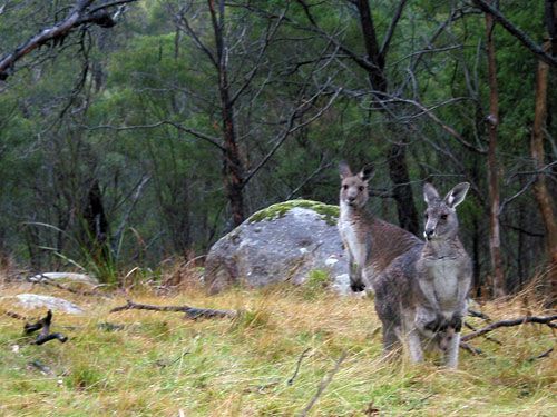
"The mountain forests of Bunyip State Park, often overlooked by bushwalkers, have a fascinating natural history with a wide range of vegetation types. these include swampy heathlands of prickly tea-tree and heathy woodlands of taller stringybar trees with an attractive understorey of Hakea, Banksia and Bush-eal. Walking through these forests is always a pleasure, the more so in spring when flowering shrubs and plants add a touch of colour."

"In Victoria buttongrass is a rarity but of all places there is a small patch lurking in a swamp not far from Gembrook. The Friends of Bunyip State Park, a volunteer community group, have constructed a first class walking track to ease passage through the wet heathlands."

Source: Day Walks Melbourne

My comments

We combined the Tree Fern and Buttongrass walks to make a reasonably easy day of walking for us. And it was just as well. Chris had sore feet and I had a headache, so something more arduous would have been quite tough.

We both enjoyed the Tree Fern Walk with its changing vegetation throughout the walk. We particularly enjoyed the atmosphere in the fern-filled gully between Windy Point and Link roads, though taking photos was a little treacherous due to slippery sloping tracks and the dim light. The track was hard to find in a couple of places (this is clearly not a popular walking track), and the directions a little unclear at times.

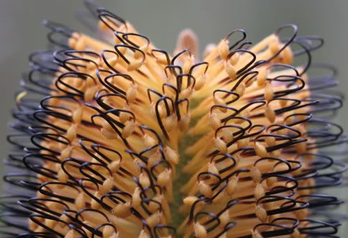
The Buttongrass Walk would probably be appreciated more by people who are more knowledgeable about native flora. However, I was pleased that there was a pamphlet available that showed the various wattle and hakea species that we saw and photographed.

My rating

Not a bad walk, but a little far to travel for a short walking day.

Photos from this walk


For more, see: Tree Fern and Buttongrass Walks photo slideshow

Saturday, July 23, 2005

Olinda Valley and Falls

Photo:

Walk overview

Length: 16.3km (two walks combined)
Time: 5 hours
Grade: Medium to hard
Ascent: 500m
Maximum height: 510m
Region: Dandenong Ranges, Victoria
Map: Melway maps 52, 66, 120, 122

"The Dandenong Ranges National Park was enlarged in 1997 when the forests around Olinda and Lyrebird Creeks were added to the park. These forests have a varied history and were lucky to survive. They were commercially logged from 1855 until 1968 when logging stopped and forest use was changed to mixed recreation."

"The native forests that remain feature Messmate and Peppermint gums. The quiet tracks provide good bird watching conditions and lyrebirds, cockatoos, parrots, tree-creepers and honey-eaters are some of hte birds that are commonly seen."

"The walk begins at Woolrich Lookout which has good views north towards Silvan Dam. It passes through the arboretum and then descends through native forest following quiet tracks and roads and returns along fire management trails."

"On the eastern side of Mt Dandenong hidden in tall forest are a series of small cascades. These are known as Olinda Falls and tracks lead to viewing platforms at both the upper and lower falls."

Source: Day Walks Melbourne

My comments

We combined two walks - Olinda Valley and Olinda Falls - to give us a reasonable walk for the day. It took us just under 6 hours to complete the 16 or so kilometres - largely due to stopping to take photos.

Fortunately, the forecast rain didn't appear and the tracks were in pretty good order. The Dandenong Ranges scenery was beautiful, as always. Again we were treated to lush ferny undergrowth and some spectacular treeferns. The Olinda Falls were pretty, and a couple of the tracks ran alongside creeks, so we were occasionally accompanied by the beautiful sound of running water.

We saw a few walkers on the shorter Olinda Falls route, but no one on the longer Olinda Valley track. I can't believe these tracks aren't more widely used - I guess winter isn't peak season for bushwalking.

My rating

A good walk that I'd definitely repeat again.

Photos from this walk


For more, see: Olinda Valley and falls photo slideshow

Saturday, July 16, 2005

Sherbrooke Forest

Photo: Footbridge over creek in Sherbrooke Forest

Walk overview

Length: 11.5km
Time: 4 hours
Grade: Medium
Ascent: 480m
Maximum height: 490m
Region: Dandenong Ranges, Victoria
Map: Melway 75, 124

"One of the most popular forests in the range is Sherbrooke Forest. From the 1850s until 1930 this forest was used for logging. In 1958 Sherbrooke Forest was declared a park and in 1987 was merged with other areas to form the Dandenong Ranges Natonal Park."

"Sherbrooke Forest contains some of the finest examples of towering Mountain Ash in this region. These are the world's tallest flowering plants growing to more than 100m in height. Many of the trees in Sherbrooke sprouted after a severe fire in 1926. Below the tall trees in an understorey of treeferns, wattles and shrubs. Birds are proflific with many treecreepers and parrots. The first is also home to the superb lyrebird which searches the forest floor for insects and grubs. This large bird is able to mimic most sounds and is commonly heard imitating other birds and man-made noises. It is sometimes seen crossing the tracks."

Source: Day Walks Melbourne

My comments

We were really lucky to get fine weather for the walk today. It had been lousy weather all week, and the rain started less than 15 minutes after we'd finished.

The walk was quite picturesque, particularly the section on the western side of Monbulk Road where we walked through a gallery of tree ferns under tall Mountain Ash forest. It got quite slippery and muddy on Hillclimb Track near Sherbrooke Falls, but other than that the tracks were in good order.

We did an extra little circuit, adding just over 2km onto the walk, and finished in just under 5 hours as a result.

My rating

A pretty walk that I'd rate easy rather than medium, and would definitely do again.

Photos from this walk

Photo filmstrip with highlights from Sherbrooke Forest walk
For more, see: Sherbrooke Forest photo slideshow

Saturday, July 09, 2005

Lysterfield and Churchill Parks

Photo: Kangaroos and joey

Walk overview

Length: 21.6km km
Time: 7 hours
Grade: Medium to hard
Ascent: 480m
Maximum height: 225m
Region: Dandenong Ranges, Victoria
Map: Melways 82, 83, 108

"Lysterfield Lake Park and adjoining Churchill National Park form a valuable walking area close to Melbourne. Due to its importance as a water catchment, the lake environs were protected from development and remain in their natural state. Churchill National Park came into existence in the 1930s. Both parks retain a precious example of natural forest and bushland and are an important refuge for much native wildlife including kangaroos, wallabies, wombats, possums, black swans, grebes and pelicans."

Source: Day Walks Victoria

My comments

My usual walking partner went skiing this weekend, so I was fortunate enough to have Mark and his daughter Claudine come along for company. I'm not too sure I'd want to do much bushwalking on my own.

The forecast was for showers, and it was raining as we drove to Lysterfield to start the walk. Unfortunately, the rain didn't let up all day. As a result, there was no stopping to take photos and only the shortest break for lunch because we couldn't find any cover.

While being a good length, the walk was rather pedestrian (pardon the pun). Many of the tracks were vehicle maintenance tracks rather than walking tracks, there was little walking uphill, and the scenery wasn't anything spectacular (a few too many glimpes of suburbia for my liking). Perhaps Lysterfield Lake would have more appeal when it isn't so wet and cold.

The main attraction was the wildlife. There were dozens of kangaroos and wallabies, many with young in their pouches. The photo above shows a little joey just poking out of the pouch of the kangaroo in the foreground.

According to our guide book, the park is usually so popular that the carpark fills up early. We were the first to arrive today, and there were only 3 or 4 cars there when we left. However, we did encounter several groups of mountain bike riders and a couple of joggers, despite the poor conditions.

My rating

OK. A little mundane to warrant another visit any time soon. We did the walk in 6 hours, and I'd rate it medium because of the length, but easy otherwise.

Photos from this walk

I didn't take any photos apart from a couple of very quick snaps of some kangaroos. It was just too wet to keep pulling out the camera.