Andrew Hill

Walk overview
Length: 11.4kmTime: 4 hours
Grade: Medium
Ascent: 450m
Maximum height: 625m
Region: Kinglake National Park
Map: VICMAP 1:25,000 Outdoor Leisure Map, Kinglake National Park
"The Wombelano Block forms the north-eastern end of Kinglake National Park. As it is just north of the Great Dividing Range it receives less rainfall than the rest of the park. The area contains a drier forest of Messmate and supports less understorey vegetation due to the lower rainfall."
"For many years this forest was logged until 1980 when it was added to the Kinglake National Park. There are a number of walking tracks which follow old roads. This was follows tracks over the forested summit of Andrew Hill which is the highest in the block."
Source: Day Walks Melbourne
My comments
We drove through rain to reach the starting point for the walk, but the weather cleared just before we began. This didn't last, however, and we had light misty rain for about 2 hours. This made the track a little slippery, but after slipping and sliding last week, this time I was prepared - I bought some walking poles during the week and wanted to try them out before trekking in Nepal. They seemed to save my knee some strain and I managed to stay on my feet for the whole walk. A fair amount of debris on the track led to a bit of tripping, and some large trees have fallen in recent months. A bridge over a gully had collapsed, though we did manage to find an alternative route. A sign would be useful. Other than this, the route was very accessible.An easy walk in pleasant surroundings, but a very long drive to get there.
Photos from this walk
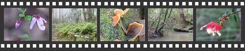
For more, see: Andrew Hill photo slideshow
Posted by Dey at 5:39 PM | Link to this post
![]()

<< Home